Showing posts with label Bridge of Dee. Show all posts

Wednesday, 26 January 2011

Contaminated.

Unfortunately, though we greatly prefer not to, from time to time necessity brings us to the Bridge of Dee Parking and Shopping Experience. It always leaves us feeling a bit dirty (metaphorically). Today, we learned that it literally makes us dirty, inside and out. Contaminated. Polluted.

Not in the least bit dehumanising.
One day soon, we'll do a full psychogeographical exposé of the zone which sits on the broad flat floodplain of the Ruthrieston Burn. But not today - we've got more indignant fish to fry.

A few years ago, following an overwhelming inflow of transatlantic capital, farmers co-operative ASDA became an arm of joint stock/private equity Wal-Mart and expanded exponentially on their site at the Bridge of Dee. Their premises and carpark were renewed and in the process part of the Ruthrieston Playing Fields was annexed. By way of a bewildering social payment sweetener the Wal-Mart management paid to also have part of the playing fields fenced off and covered in astroturf. Something to do with the formal to the real subsumption of leisure (as well as labour) under capital, probably.

We walked past this privatised and artificialised part of the playing fields on our way back to Pitmuxton via the Old Deeside Line. And a horrifying sight transfixed us.

Eeewww!

A great deal of snow fell on Aberdeen during November and December, and that snow, having been cleared from the pathways and carparks and the astroturf surface was piled up in huge berms. Over the weeks since, these snow-piles have been melting and leaving their formerly hidden toxic payload in situ.

This cargo of filth, this residue of disgusting dirt was consigned within the snow which had pulled it, dissolved it, from the very atmosphere through which it fell and which surrounded it as it lay in drifts and piles. Hidden in the pure white drifts and blankets, this toxic lading was concealed, now revealed as the water and ice which fixed it from the sky dissipates.


As we survey the huge double-deck Wal-Mart carpark, the carpark of Boots and PC World, the carparks of B&Q and Sainsbury's, so close to the playing fields where youngsters run and shout (albeit on an artificial surface, behind a fence, their leisure bought and paid for and itself generating revenue) we need not ask the source of this polluting filth, this literal and metaphorical stain.

But what we should ask is whether it is right for young people to be exercising aerobically in such a polluted atmosphere. We will not waste our effort in calling for a reduction in the provision of parking spaces; the exigencies of local realpolitic are far more likely to acknowledge the "facts on the ground" and close the playing fields - thus allowing Wal-Mart to further expand their car-park.

Splendid.

Monday, 24 January 2011

Rubislaw Quarry. Update.

A lovely day for a look at the quarry loch.


Some months ago, we conducted a thought experiment with the water in Rubislaw Quarry Loch as the subject.

We'd been prompted by news coverage that the quarry loch had been purchased by Sandy & Hugh, friends of a friend of a relative of ours. They refused to confirm exactly how much they'd paid, only going as far as saying that it was "less than a one-bedroom flat". A reasonable answer to why anyone would want to buy such an obvious liability was, similarly, not forthcoming.

So we'd gone and had a look at the site where the great part of the stone for Aberdeen's 19th and 20th century buildings had been extracted. We were impressed by the level of water which had filled the 200 metre deep hole. Indeed, by dead reckoning from our viewpoint we could see that the level of water was higher than Aberdeen's prestigious, upscale Queen's Road, which orbits the south of the site.

This might be something to be concerned with, as we darkly fantasised at the time. [For those not familiar with Aberdeen - this site is in the very centre of the affluent and aspirational "West End" of the town. Just to the west of the town centre; an area of tree-lined avenues, stately terraces and the modernist offices of Big Oil. This is an inner urban issue.]


Returning to view the quarry loch some six months later (again, to our chagrin, neglecting to bring along the Other Aberdeen theodolite) we were forced to use dead reckoning and pour over the photographic evidence which we gathered. Loupe to eye, we can confirm that, in our opinion, the water level has risen about 1.5 metres in the last six months.

Is this really a cause for concern? Truthfully, we don't know. But what we can say is that published minutes of Queens Cross/Harlaw Community Council for November and December 2010 reveal that the Community Council has significant concerns.

It seems that since November 2010, the Community Council has been in disappointingly one-way correspondence with Sandy & Hugh regarding their intentions for the quarry loch, and seeking information on whether any progress had been achieved in their discussions with civil engineers at Aberdeen University regarding means of permanently reducing the water level.

No response has been forthcoming from the grinning new owners who say they want to "share" the quarry loch with the residents of Aberdeen. Just what form this "sharing" will take is what worries us!

Sandy & Hugh: Silence.
Living in the heart of upscale downtown Pitmuxton (down the hill from Rubislaw), as we do, we'd very much like to have an answer from Sandy & Hugh.

We can attest that the Damoclean threat of two megatonnes of water thundering down the valleys of first the Holburn, then Geldieburn then Newlands burn and Ruthrieston Burn on the way to washing the entirity of the Bridge of Dee parking and shopping experience into the Foords of Dee is an intolerable source of fretful stress to the residents of Pitmuxton, and may have an adverse impact upon the upscale and aspirational character of the neighbourhood, thus rendering it less nice. (But what really bothers us is that Ferryhill is well out of the way of this threat. Dammit.)

We'll be following the future minutes of Queen's Cross/Harlaw Community Council with close attention.

Wednesday, 8 December 2010

Geldieburn Unbound


The open area at Foords o' Dee (beside the Bridge of Dee) is looking great at the moment. This is an interesting area, with lots of histobunk and stuff, which we promise we'll examine in detail when the season improves.

That's the outfall of the Newlands Burn. By the Ruthrieston Pack Bridge.

Anyhow, when we were down there at the weekend, we were in the area where the Geldieburn outfall deposits its flow into the Dee. Unfortunately, the snow and ice prevented us from locating the outfall or from seeing the water of the Geldie actually flowing. Bah.

The Geldie outfall. Under there somewhere.
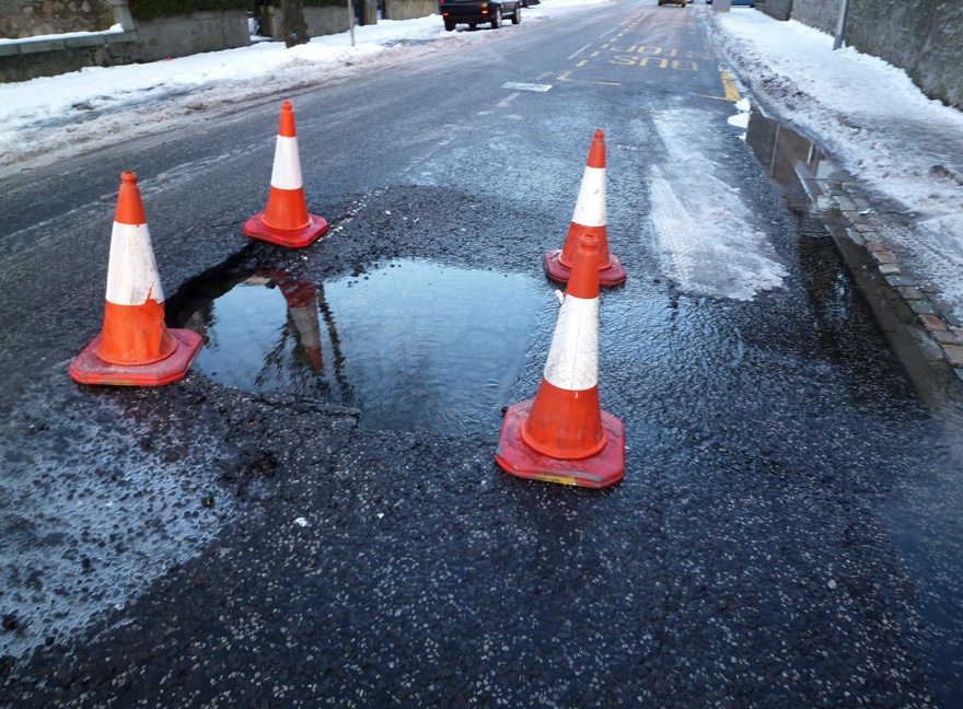
However, the psychogeographical gods were similing on us that day, and as we walked up the south-facing slope that is Pitmuxton, we noticed that Broomhill Road had been disrupted by something bad happening to the carriageway.

It's the Geldie! We did get to see it's water flowing after all!
Yay!
According to the Scottish Water engineers who showed up to try to fix it, the culvert which carries the Geldieburn underneath Broomhill Road close to Salisbury Terrace had collapsed.

By later in the day, the situation had worsened.


By monday, the culvert had been cleared and the Geldie was back in bondage, but the carriageway cannot be repaired until the temperature rises above freezing. A light control has been installed, much to the frustration of the tea-time commuters hurrying home in time for The Simpsons.


And we thought that only cyclists went through red lights!