Showing posts with label Westfield. Show all posts

Monday, 23 August 2010

March Stones 26 and 27 ABD - Brotherfield

In common with other cities, notably Washington DC, the historic borders of Aberdeen are marked with boundary stones - The March Stones. ("March" being mid-Scots for "boundary" or "border").

The March Stones are said to mark the boundary of lands granted to the Burgh of Aberdeen by Robert the Bruce.

The westernmost of the March Stones are at Brotherfield.

Click for a bigger version.

Stone 26 ABD is at the confluence of the Ord Burn and Silverburn. 


Stone 27 ABD is one of the more recently-made stones, its predecessor presumably having been swept away by the Ord Burn which it borders. There had been a fair bit of rain in the few days before we visited, and the burn was roaring in spate. Aside from the style of the carving, one aspect of the newer stones is that they do not follow the convention of facing inwards, towards the burgh. That is, in order to read the inscription on the older stones, one must be standing within the border. 

In order to see the inscription on Stone 27 ABD, one must be standing outwith the border. Not that it really matters.


Stone 27 ABD used to mark an artifact known as 'The Ringing Stone'. The origin of the name has been lost in time, along with the stone itself, but stones which 'ring' with a tone when struck are not uncommon - there are 'rock-gong' sites all round the world. Indeed, the recumbent stone at the Tyrebagger stone circle is a 'ringing stone'. There's an article in this week's New Scientist about the importance of acoustics and sound design to our prehistoric ancestors. The article touches on 'rock gongs', so it's worth a read in this context.

While we were in the area, we took the opportunity to re-visit the site of Stone 21 ABD and got a proper photo of it. Cattle-saliva and bird-lime smeared though it is...


Then, as you can see, the weather closed in on us...

Click for a bigger version.

From Beans Hill, you can see all the way to Lochnagar. Weather permitting.

Wednesday, 18 August 2010

March Stones 21 to 25 ABD - Beans Hill and Silver Burn - The Bypass Lands

Continuing our exploration of the border of the medieval burgh of Aberdeen "The Marches" (march=border) we find ourselves at Beans Hill, between Countesswells and Peterculter. The border is marked by 67 'March Stones'

There's plenty information available online about the March Stones. Aberdeen City Council have a leaflet which details a couple of walking trails. You can download a PDF here. (Health warning - there are a couple of errors on the leaflet).

The Leopard mag has an excellent article about the history of the March Stones which we recommend.

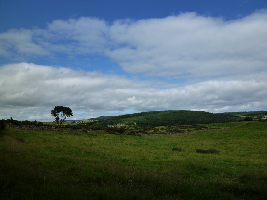
Anyhow; Beans Hill. It's a picturesque and serene area, but won't stay that way for long as this where the Aberdeen Western Peripheral Route will skirt the city on its way from Peterculter to Kingswells.


We recommend a visit if you can, before the character of the area is changed forever. Bone up on the Scottish Outdoor Access Code (PDF), get some old clothes and sturdy shoes on and off you go!

We left off last time with Stone 20 near Westfield Lodge, which is a very strange place.


Stone 21 is in the middle of a field, which, unfortunately on the day we visited was hosting an herd of bullocks. As we were, ahem, quite brightly dressed in our mountain bike gear, we didn't fancy our chances intruding on their space, so we'll have to make do with this telephoto and digitally zoomed image of the back of the stone. Let's say that this is a placeholder image, and we'll return for a proper photologging of the stone when we can. A bit disappointing.


Edit:

Here it is - no bullocks in the way this time:


Stone 22 is actually in the same field, but the bullocks were a couple of hundred metres away, over a rise and out of line-of-sight, so we vaulted the dry stane dyke for this shot. You can see that the bullocks have been licking the stone. As they do.


From there, it's a bit of a trudge up Beans Hill. Looking back to the south-west down the route of the march-line:


That photo was taken from a site which will become the western embankment of the AWPR - where it intersects the greenery in the centre of this drawing.


Stone 23 is at the summit of Beans Hill. Unfortunately you have to negotiate this labyrinth of barbed wire and gorse to get there. Gloves are a really good idea.


We were looking forward to finding stone 23, as it is described as having a 'saucer-marked' stone next to it. These ancient stones are part of the natural geography of the landscape and are prominent features, so it was natural for those setting land borders to use them, along with water-courses and other features, as markers which helped define the border. The 'saucers' are depressions carved or ground into the natural stone. No-one's really sure what their function was, but some speculate that they were filled with molten lead into which the city's coat-of-arms was impressed.

Here's Stone 23 at the summit. It looks like that's the more ancient 'saucer-marked' stone beneath the ABD marked stone. A previous visitor has peeled back some moss to reveal more of the stone, but we can't see a saucer mark here.


Hold on, what's this?


The saucer-mark is about four feet from the ABD stone. It's covered with a thick coat of moss, which is beginning to form a topsoil layer which grass has colonised.


The saucer stone is really quite large. The biggest we've come across so far. It came as a surprise to discover that we'd been standing on it for some time.


Stone 24 is over the summit of Beans Hill and down the slope towards the Silver Burn. It's close by North Westfield house. The couple who live there were delighted to chat.


Stone 25 is accessed from East Brotherfield farm. Again, the farmer was delighted to chat and pass the time discussing the stones and the dreaded coming of the bypass. It really is a delightful area, and we can't help but feel for the residents who's tranquility will be shattered and life changed forever by the building of the new road.


Stone 25 is on a hillock in a field of cows. Young heifers this time, so nothing to fear. But if you go there - please be sure to speak with the farmer first. Very important.


Unlike at stone 23, where it's covered in moss and not at first apparent, the saucer stone at 25 is prominent and rather obvious.

Can you see the saucer-hole?

Behind the saucer stone, we find a poignant memorial to an earlier march-tramper.

Monday, 2 August 2010

March Stones 16 to 20 ABD - Murtle Den and Westfield


Time to go off-road in search of more March Stones. Having skulked around Cults and Bieldside, becoming alienated with suburban ennui in search of stones 12 to 15, we were glad to get off the beaten track in search of those stones which are in undeveloped areas.

Here's the histobunk bit:
The March Stones mark the boundaries of the 'Freedom Lands of Aberdeen'. It is said that once Robert the Bruce had cleared the royal forests surrounding the city of all the interesting and valuable/tasty game, having no further use for the hunting grounds, he 'gifted' them to the Burghers of Aberdeen. For a yearly rent. The Leopard Magazine will tell you more about this. Read it here.

If you're going to go looking for these stones 16 to 20, you do so at your own risk. You will get wet and dirty, your feet will sink into bogs, you will tear your clothes (and possibly your skin) on barbed wire. You will find yourself clambering over consumption dykes and rubble cairns and you will become mentally and physically exhausted from the search. A moderate level of fitness (at least) is required.

Having said all that, you will gain a sense of achievement, and see some of the more ancient 'saucer-marked' stones. So bone up on the Scottish outdoor access code (PDF), get on some sturdy shoes and old clothes and off you go! We used XC hardtail mountain bikes to access some of the sites. Be warned, they are totally inaccessible by car. Do not try.

We were given a bum steer by the council's leaflet "Aberdeen's March Stones Trail" (PDF) with regard to the location for access to stone 16 ABD. So, ignore the leaflet and use an Ordnance Survey map (Explorer Sheet 406) instead, where the location is accurately plotted and best access to it is obvious. Contractors were digging a swimming pool(!) in the garden of the large house closest to the access to the boggy ground where the stone lies, so we had a word with them, just so they knew we weren't up to anything nefarious. The gaffer knew what we were on about, and was delighted to wish us good luck on our search.

We got lucky. We didn't have to search the boggy ground where the stone lies at all, we walked directly to it. Just luck.


The ABD marked stone sits adjacent to a 'saucer-marked' stone. These are 'first generation' boundary markers - natural features such burns, glacial erratic stones and outcrops were supplemented by cairns. The stone which survives next to the 16 ABD marker is one of these erratics, and has been marked with a 'saucer'. Some archaeologists speculate that the 'saucer' would have been filled with lead, and then the city's seal impressed into the lead.

The saucer is full of moss.

Stone 17 ABD is in an area full of granite rubble, at the confluence of two burns. Very boggy. Very difficult to access. Again, we were lucky to find the stone quickly.


Stone 18 ABD. Inside a field of barley, close to the den of the Murtle Burn. Sharp eyes required to spot the location.


It's close to the western end of this consumption dyke.

Having the saucer stone next to the ABD marked stone, the location is accurately marked on the Ordnance Survey map.


The site had been recently visited. The crop immediately around the stone had been tramped flat in an anti-clockwise direction all round the site. And the saucer-hole was filled with a buff-coloured chalk-like substance.

What's that all about, then?

Stones 19 ABD and 20 ABD are on the southern boundaries of fields immediately south of Westfield Lodge.


Westfield Lodge is weird.